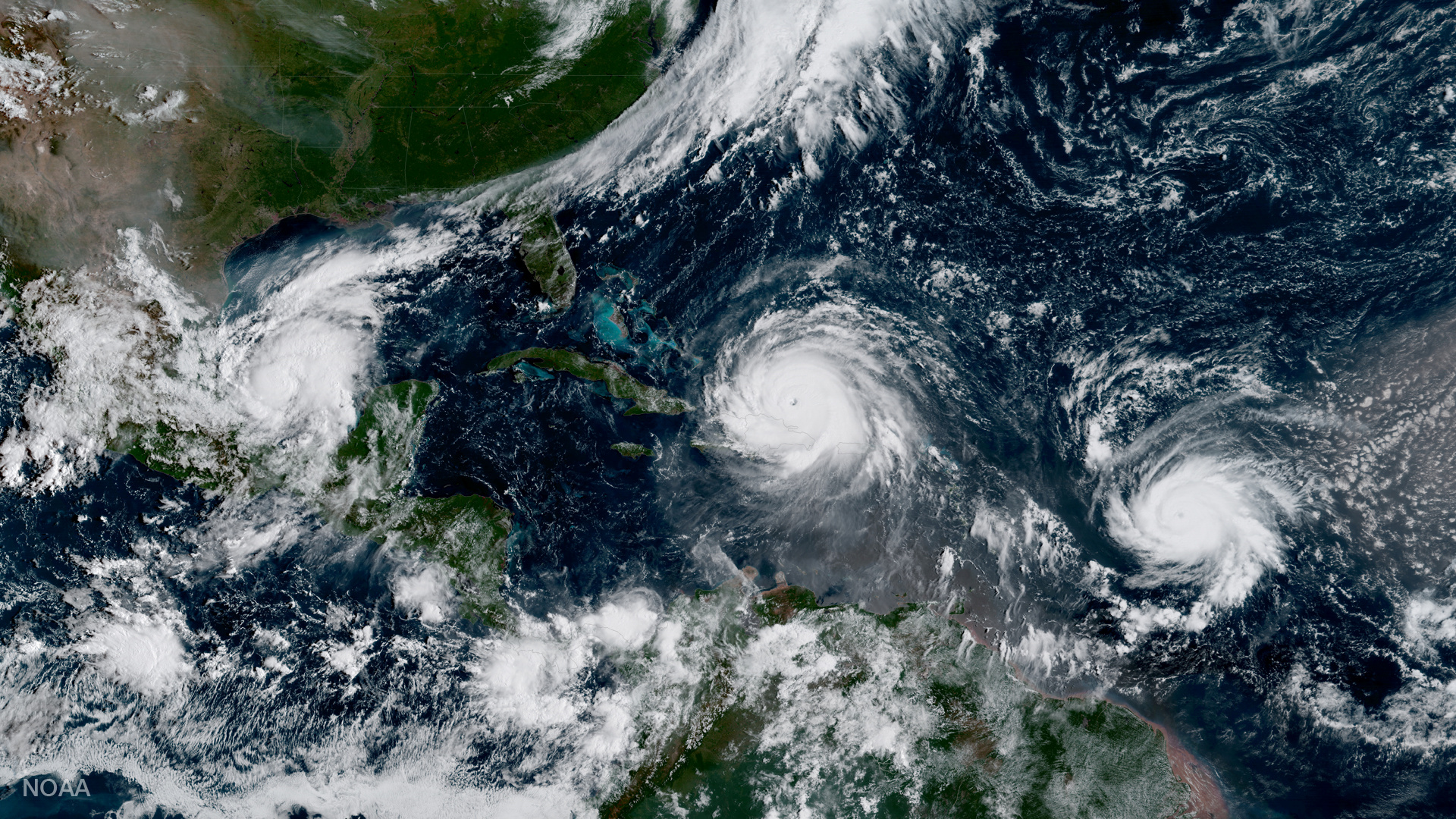
New satellite imagery shows the unusual sight of three hurricanes spiraling in the Atlantic at the same time.
The National Oceanic and Atmospheric Administration (NOAA) released satellite photos Wednesday of Hurricanes Irma, Katia, and Jose—including one showing all of them in the same image.
The image, distributed by NOAA’s National Hurricane Center in Miami, provides an awe-inspiring look at Mother Nature’s power and the vulnerability of all the land in their paths. This satellite image is from 4:55 PM EDT on Sept. 6.

Additional satellite imagery from the Short-term Prediction Research and Transition Center, a NASA weather-related project, also shows the three Hurricanes spaced across a couple thousand miles of ocean.
We now have 3 hurricanes in the Atlantic: #Katia (left), #Irma (center), and #Jose (right). #GOES16 pic.twitter.com/139CRos9Ap
— NASA SPoRT (@NASA_SPoRT) September 6, 2017
We now have 3 hurricanes in the Atlantic: #Katia (left), #Irma (center), and #Jose (right). #GOES16 pic.twitter.com/139CRos9Ap
— NASA SPoRT (@NASA_SPoRT) September 6, 2017
Hurricane Irma, a Category 5 storm with winds at speeds of 185 miles per hour, is passing through the northern Caribbean islands, with CNN reporting Wednesday afternoon that the devastating storm has already caused at least two deaths and two serious injuries.
Get Data Sheet, Fortune’s technology newsletter.
Weather forecasters predict Hurricane Irma will eventually reach Florida and other nearby U.S. states.
#GOES16 captured this colorized-infrared imagery of #Irma approaching #PuertoRico this afternoon. Latest info @ https://t.co/cSGOfrM0lG pic.twitter.com/FsmhhzCiAb
— NOAA Satellites (@NOAASatellites) September 6, 2017
#GOES16 captured this colorized-infrared imagery of #Irma approaching #PuertoRico this afternoon. Latest info @ https://t.co/cSGOfrM0lG pic.twitter.com/FsmhhzCiAb
— NOAA Satellites (@NOAASatellites) September 6, 2017
Hurricanes Katia and Jose are both Category 1 storms with sustained winds of 75 miles per hour. Hurricane Katia formed in the southwestern area of the Gulf of Mexico and is expected to hit Mexico’s coast by Thursday, according to the Associated Press.
Here's a look at #Hurricane #Katia on satellite this afternoon. pic.twitter.com/ucvh0LAzs7
— Andrea Butera (@AndreaButera) September 6, 2017
Here's a look at #Hurricane #Katia on satellite this afternoon. pic.twitter.com/ucvh0LAzs7
— Andrea Butera (@AndreaButera) September 6, 2017
Hurricane Jose is currently hovering over the Atlantic Ocean about 1,000 miles east of the Lesser Antilles in the Caribbean, according to The Weather Channel. Forecasters predict that Hurricane Jose will become more powerful by the weekend.
Here's a look at #Hurricane #Jose on satellite this afternoon, plus its forecast track via the NHC. https://t.co/dISUwW8gBl pic.twitter.com/vtKE9VtMv4
— Andrea Butera (@AndreaButera) September 6, 2017
Here's a look at #Hurricane #Jose on satellite this afternoon, plus its forecast track via the NHC. https://t.co/dISUwW8gBl pic.twitter.com/vtKE9VtMv4
— Andrea Butera (@AndreaButera) September 6, 2017